The land itself
A good valley with reliable water
The Tucker homeplace sits in the rolling Appalachian foothills of southern St. Clair County, where the land runs in long wooded ridges and narrow farmable valleys — ridge-and-valley country, with limestone underfoot and springs that stay wet even in a dry summer. A small stream the family calls Stovall Branch runs through the back of the place, and a spring rises right beside where the old home once stood, trickles down the mountain, and crosses under the road at the low point below.
That water is the whole reason for everything that follows. Reliable, clean water in a sheltered valley is exactly what draws people to a place and keeps them coming back — a herd of deer, a Creek hunting party, a Carolina family looking for farmland, a family reunion. Long before there was a deed, a road, or a name on a map, this was simply a place worth stopping.
For most of its history this valley was known for three things in sequence: Creek hunting country, then frontier farmland, then a farm-and-rail community feeding the Birmingham iron boom just over the ridge.
Before 1814 · Creek country
Muscogee homeland
For thousands of years before any European set foot here, this valley lay within the territory of the Creek (Muscogee) Nation, in the western reaches of Creek country near the Coosa River. The Coosa valley was the heart of the historic Abeika, or Upper Creek, towns — and the river still carries a Creek name, drawn from the Native towns that stood along it.
This part of Alabama was laced with Native American trails long before it had a single road. When white settlers finally came, they didn't cut new paths through the wilderness — they simply followed the ones already worn into the ground. County histories record trails running from the old Creek village of Cataula (the site that became Ashville, the county seat) toward Cropwell, and up from the Coosa toward what's now the Friendship community — the same Friendship where our earliest Tuckers are buried. As late as January 1817, travelers were still stopping at a spring near "the old Creek Indian town of Cataula." One of those old Indian trails survives today as Beaver Valley Road; some of the first homesteaders in the county literally located their land at the crossing of two of them.
Which brings it home to our own ground. That spring beside the old homeplace, and Stovall Branch below it, are exactly the kind of dependable water where Native families camped, season after season, for millennia. It is entirely possible that worked stone — arrowheads, tools, flakes — still rests in this soil, especially near the spring, along the branch, and in freshly turned earth after a rain. When you walk the place, you're walking ground that people have valued for far longer than there's been a Tucker on it.
1813–1814 · The Creek War
How the land opened
The door to white settlement was thrown open by the Creek War of 1813–1814 — a conflict that was at once a civil war among the Creeks (the militant Red Sticks against more accommodationist towns) and a front of the larger War of 1812. After the Red Stick attack on Fort Mims in August 1813, General Andrew Jackson led a campaign that ended in his decisive victory at the Battle of Horseshoe Bend in March 1814.
The war ended with the Treaty of Fort Jackson, signed August 9, 1814. It forced the Creeks — including the allied Creeks who had fought alongside Jackson — to cede more than twenty-one million acres in present-day Alabama and Georgia to the United States, including a huge block west of the Coosa River. St. Clair County was carved out of that cession. And many of the very first settlers to arrive were veterans of the Creek War itself, taking up land grants in the country they had just campaigned through.
It's worth saying plainly: the ground our family has loved and kept for generations came to be available for settlement because it was taken from the Creek people. Both things are true at once — our gratitude for this place, and an honest accounting of how it came open. Holding both is part of being a good steward of the story, not just the soil.
1817–1824 · The frontier
How it was homesteaded
St. Clair County was created on November 20, 1818, out of Shelby County, and named for Arthur St. Clair, a Revolutionary War officer. The first settlers had already begun trickling in the year before. Most came overland from Tennessee, Virginia, and the Carolinas, following the old roads and the older Indian trails, and they took up land the way the frontier was settled everywhere: the government surveyed it into six-mile-square townships, divided each into thirty-six one-mile sections of about 640 acres, and conveyed it to settlers — often by cash entry, sometimes by grant to a war veteran.
Right at what would become Odenville, the story has a name and a date. A blacksmith and Presbyterian preacher named Peter Hardin came in with the first band of settlers in 1821, and by 1824 the Hardin family had set up a blacksmithing and cabinet-making shop at the spot that is the town today. Everyone called it “Hardin's Shop.” Peter had thrown in his lot with the family of a Methodist minister, Christopher Vandegrift, who had left Chester County, South Carolina in the fall of 1821 to come west — and Peter married Christopher's daughter Ellen that November before they made the trip.
That Carolina-to-Alabama road is our road too. Joseph Russell Tucker — the man at the very top of our family tree — was born in South Carolina in 1804.
He was of exactly the same generation and the same migration as the Vandegrifts and the Hardins: Carolina families pulling up stakes for the newly opened Alabama frontier. Joseph Russell Tucker ended his life here in St. Clair County — he died in 1863 at the place remembered as “the Tucker Place, St. Clair Springs,” killed by the Civil War Home Guard, while his wife Rachel later moved on to Texas. By the time of his son Samuel Johnson Tucker (1827–1907, a Confederate veteran buried at Friendship Baptist), the family was firmly rooted in this county — and it was Samuel Johnson's son, Samuel James “Jim” Tucker (1871–1960), who with Fannie Lou Mewbourne raised the eleven children whose descendants are reading this page.
1850s–1900s · Cotton, rails & iron
A farm-and-rail community
For its first century, this was farm country — cotton, corn, cattle, and timber worked out of those narrow valleys. Odenville got its post office in 1890 and, with it, finally settled on a name (“probably after a local family,” the records say — no one is entirely sure who). The first cotton gin went up in the early 1890s.
Then the railroad changed everything. The Seaboard line came through Odenville between 1901 and 1905, and a farm town suddenly had a way to ship to the world. A bank opened in 1908, telephones arrived around 1912, and Odenville incorporated in 1914. Just over the ridge, Birmingham was roaring — the great Southern boom in coal, iron, steel, and limestone — and St. Clair County, sitting on the mineral district's doorstep with rail access, fed people, farm goods, and stone into it. The same limestone that lies under the homeplace valley is a cousin of the limestone that fluxed the Birmingham furnaces.
This is the world Jim and Fannie's children grew up in — a farm on the old family land, a railroad in town, and the iron city glowing over the hills. Some stayed on the land; some, like Lee, went to work in Birmingham (forty-four years at U.S. Steel); the whole family stayed tied to this valley.
1918 to today · Our stewardship
The Tuckers on this ground
The land came down through the family the way good land does — held, worked, and handed on. In 1997, Frederick Lawrence “Fred” Tucker — the “Frederick L.” on the deed — saw to it that the fifty-nine-acre homeplace was deeded to the family through The Tucker Foundation, Inc. (formed the year before, in 1996), so it would belong to all of us rather than pass out of the family. Four adjoining parcels, one shared inheritance. Family land still sits right alongside it: cousins hold tracts in the original homeplace block to this day.
And so the valley has come nearly full circle. The spring still runs. Stovall Branch still crosses under the road. Deer still work the ridges. Somewhere in the turned earth near the water, there may still be a worked stone from a family who camped here three thousand years ago. We are only the most recent people to love this place — and, if we do it right, not the last.
We owe a real debt to everyone who came before us — the ones who homesteaded it, kept it in the family, gave the land, paid the taxes, cut the road, and cleared the paths. May we be as good to it, and to each other, as they were to us.
The short version
This land, by the years
- pre-1814Creek (Muscogee) homeland — hunting country, laced with trails, camped along the springs for millennia
- 1813–14The Creek War; Horseshoe Bend; the Treaty of Fort Jackson cedes 21+ million acres
- 1818St. Clair County created, Nov 20, out of the cession
- 1821–24Peter Hardin & the Vandegrifts (from Chester Co., S.C.) settle — “Hardin's Shop”
- ~1804Joseph Russell Tucker born in South Carolina — the top of our tree, of that same migration
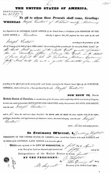
- 1850Joseph Russell Tucker patents Section 2, T15-S R2-E — the progenitor's own federal land grant of the homeplace ground (more Tucker patents in Sec. 1 & 2 by 1858)
- 1863Joseph Russell Tucker dies at “the Tucker Place, St. Clair Springs”
- 1890Odenville post office; the name is settled; cotton gin follows
- 1901–05Seaboard Railroad built through Odenville; the Birmingham iron boom over the ridge
- 1914Odenville incorporates
- 1996–97The Tucker Foundation forms; Fred Tucker deeds the 59-acre homeplace to the family
Where to next
Keep exploring
Sources & honesty
Where this comes from
This history is stitched together from public records and reputable local histories — including the family's original 1850 federal land patent (Bureau of Land Management, General Land Office records) and the 1850 U.S. Census that ties it to Joseph Russell Tucker. Where the record is still thin — the precise origin of the name “Odenville,” whether Stovall Branch is named for the Stovall family at nearby Liberty Church — we've said so rather than guess. Corrections and additions from the family are always welcome.
Encyclopedia of Alabama (St. Clair County, Odenville, Creek War, Treaty of Fort Jackson) · American Battlefield Trust, The Creek War · Discover St. Clair (First Families, In the Beginning — Ashville, Odenville) · City of Odenville — History · Anniston Star, “The history of Odenville and its first settlers” · Wikipedia — St. Clair County · Encyclopedia of Alabama — Iron & Steel · Bureau of Land Management, General Land Office Records (for the land-patent lookup still to come). Full research notes are kept with the family's private history file.